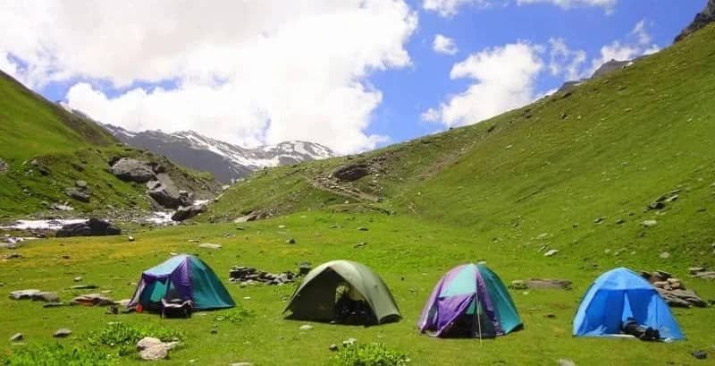
Suraj Tal, also known as Tso Kamtsi or Sun Tal. It is an 800-meter-long lake and is a divine lake. The lake is in the Lahaul and Spiti district of the Indian state of Himachal surrounded by breathtaking valleys and majestic mountains. Suraj Tal is situated at an altitude of 4,890 meters. The lake is located just below the Bara-Lacha-La pass. Suraj Tal Lake is the third-highest lake in India and the 21st-highest lake in the world. And Suraj Tal is 65 km from Keylong. The best time to visit Suraj Tal is from mid-April to September and you can go by bus or by your own car.
Suraj Tal Lake Lahaul Valley Himachal Pradesh
Lake is just below the source of the Bhaga River and joins the Chandra River. The Chandrabhaga River is also called the Chenab River and enters the Jammu region of Jammu and Kashmir. Leh-Manali National Highway NH 21 can be reached here. It is also revered as the lake of the Sun God and taking a dip in this holy lake can absolve you of all sins. This lake covered with layers of snow looks no less than a paradise. The journey from Manali to Suraj Tal is very beautiful. Its experience will never be forgotten. The journey from Manali to Keylong and from Keylong to Jispa to Deepak Tal is very beautiful. And then the steep climb from Deepak Tal to Suraj Tal and the surrounding mountains covered with snow, the view is very beautiful.
Most trekking enthusiasts make the Manali-Leh highway their base camp. The roads to Zanskar, Ladakh, Spiti, and Lahaul meet at this pass. In addition to flowing through the Bhaga River and Suraj Tal originating from it, the Bara-Lacha-La Pass is also the source of the Chandra and Yunan rivers to the southeast and north, respectively. The lake is a beautiful paradise for trekking, photography, and nature lovers. Coming here is like giving peace to the soul. The lake comes on the way of the Manali-Leh route and hence is very popular. You can never forget the beauty of Suraj Jheel.
Geography
The lake is located in the high latitudinal part of the upper Himalayan region, which is sparsely populated. There is snow throughout the year in this region. Rainfall is moderate and snowfall is reported to be less than 200 mm. However, an observatory in the area reported 800 mm (31 in) of snow. From May the rains begin to melt and the snow on the slopes usually loosens. The average total snowfall recorded in a year is 39-49 feet and the highest temperature is 13°C. The average highest temperature is 0.5 °C and the average minimum temperature is -11.7 °C and the lowest temperature is -27 °C. The ground of the area is covered with pebbles and boulders.
Geology
The geology of the lake is similar to that of the nearby Bara-Lacha-La Pass, which has been described as an early rift event on the northern Indian passive margin and indicates basalts located along trans-tensional faults.